Muskie and walleye on a drive-to lake with a protective slot limit.
Free printable map (PDF) ↓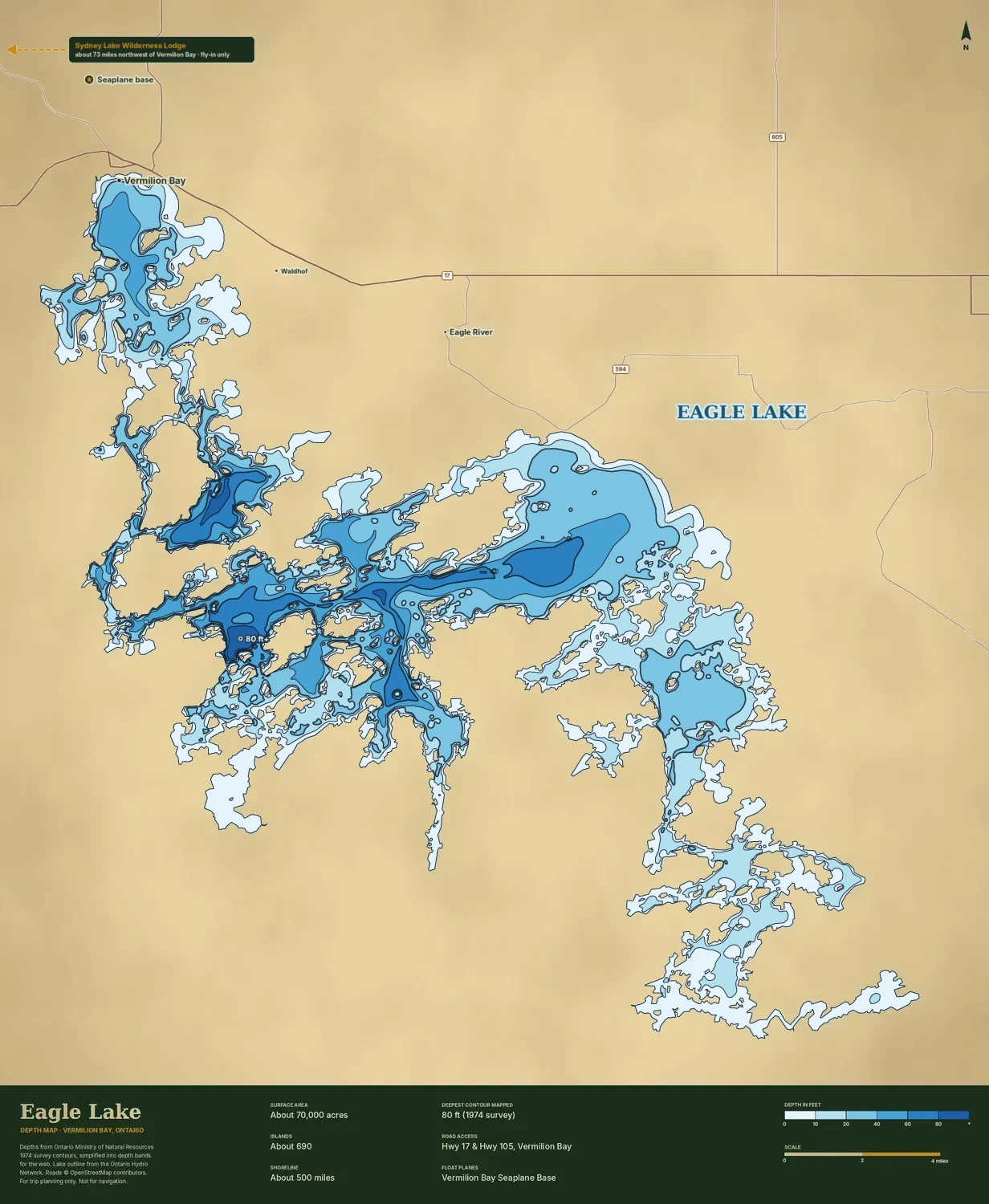 Download the free printable map (PDF) ↓
Draft map. Depth bands where a public survey exists; each map has its own scale bar.
Where: Northwestern Ontario · Vermilion Bay
Size: about 70,000 acres
Access: Drive-to: Highway 17 and Highway 105 at Vermilion Bay; public launches and resorts.
Deepest: 110 ft
Average depth: ?
Species to target: Walleye, northern pike, lake trout
Walleye limit (US angler): 2; release 46–58 cm, 1 over 58 cm
Typical ice-out: ?
Who else is on the water: many resorts
Size (acres)
Sydney & Kilburn: about 17,570 (Sydney 14,240 with the Sturgeon River + Kilburn 3,330)
Eagle Lake: about 70,000
Boats on an average summer day
Sydney & Kilburn: 10
Eagle Lake: ?
Acres per boat
Sydney & Kilburn: 1,760
Eagle Lake: ?
Rough-water days a season
Sydney & Kilburn: 1.7 (Kilburn 0) ✓
Eagle Lake: 1.8
Sheltered water
Sydney & Kilburn: 75% ✓
Eagle Lake: 74%
Walleye a US angler may keep each day
Sydney & Kilburn: 2, both 18 in or under
Eagle Lake: 2; release 46–58 cm, 1 over 58 cm
Clearest summer water
Sydney & Kilburn: 26 ft ✓
Eagle Lake: 17 ft
Deepest spot
Sydney & Kilburn: 240 ft (Kilburn 213 ft) ✓
Eagle Lake: 110 ft
Cisco (tullibee)
Sydney & Kilburn: ●
Eagle Lake: ●
Whitefish
Sydney & Kilburn: ●
Eagle Lake: ●
Free of invasive smelt
Sydney & Kilburn: ●
Eagle Lake: ●
Mayfly mud flats
Sydney & Kilburn: ●
Eagle Lake: ?
Disturbances on or upstream (of 6)
Sydney & Kilburn: 0 ✓
Eagle Lake: 2
Typical ice-out
Sydney & Kilburn: about May 5
Eagle Lake: ?
Hours from Minneapolis
Sydney & Kilburn: 7 h drive + 0.5 h flight
Eagle Lake: 7.5 h drive
Who else is on the water
Sydney & Kilburn: 1 lodge, 0 cottages
Eagle Lake: many resorts
✓ marks the better value. ? means we couldn’t find accurate data or a close estimate. We’ve made every effort to be accurate, but some figures are estimates and there may be errors or gaps. How we measured